Memory 05
Trajectory
LAUNCH TRAJECTORY, REASONS FOR, AND IMPLEMENTATION
     	POLAR ORBIT– METHOD, DOGLEG
			RADIO GUIDANCE STEERING
	VELOCIMETER, MARMON CLAMP
	SKIN TRAK - FIRST ALERT ON ORBIT
		4 PIECES REPORTED BUT OK LATER
	GOOD ORBIT PREDICT  GRAPHS/TABLES
	COMMENT BY OFFICER
	ATLAS AND AGENA BOOSTERS
	REV 1 GLITCHES – PADLOAD  ISSUES AND SKIN TRACK 			USE
Some readers of this treatise (and others) might wonder why the vehicles of programs such as Gambit and other early programs performing similar type missions were launched into a polar orbit from Vandenberg Air Force Base in California rather than Cape Canaveral Air Force Base in Florida. There are probably several reasons, and, having worked on several programs whose vehicles launched from Vandenberg, I will list some reasons that, perhaps, made Vandenberg Base a better option. Some of these reasons are derived from discussions with former co-workers, some are from technical and political posturing articles I have read over the years, and my thoughts after following this issue for many years. The “political posturing” came to my attention on reading several NRO documents describing Florida Congressional leaders as asking why not launch from Florida, seeing contracts and jobs going to the West Coast.
Looking at a map showing North and South America and noting the land masses South of Cape Canaveral and Vandenberg, one can see that looking south toward the South Pole from the Cape Canaveral area, that if a launch south toward the South Pole occurred and a booster malfunction occurred shortly after launch, the errant booster with a satellite still attached to it could easily impact the earth in land masses south of Florida. This would likely have international repercussions if something was damaged or someone was injured or worse by the uncontrolled satellite returning to earth in another country. Some countries under the vehicle trajectory south of Florida might think they were under attack, or at least, not be happy with uncontrolled debris falling around them.
Looking south toward the South Pole from the Vandenberg area, note that if a launch south toward the South Pole occurred and a booster malfunction occurred shortly after launch, the errant booster with a satellite still attached to it would have much less land mass to impact on than on a similar event from Cape Canaveral. I feel the potential for problems internationally was one strong factor favoring launches from the West coast. A second reason was security related. A launch from Cape Canaveral would likely have more press coverage than one fromVandenberg Base due to the NASA activity at the Cape at that time, including Gemini and Apollo activity, which had lots of press coverage and any launch from there, particularly a classified launch, would probably have involved much more coverage than desired.
I will admit that I am likely biased for West Coast launches, having visited Vandenberg more than a few times during my Gambit KH7 days, and visited Cape Canaveral only once, early in my career, a few weeks after Scott Carpenter visited space on NASA project Mercury.
In order to decrease the chance of an uncontrolled satellite and boosters from impacting on a land mass on launches from Vandenberg, a penalty of sorts was paid. The initial launch trajectory from Vandenberg was south and slightly west; then when the vehicle had cleared land mass and was over water, a ground radar tracking and commanding system commanded the thrusters on the booster to turn the thrusters to perform a “dogleg” maneuver to the left which sent the satellite on a more southern trajectory. This trajectory caused the satellite to traverse over the South Pole area closer to the South Pole and into the desired orbit for better access to imaging areas.
The penalty incurred was in launching slightly southwest at start of the launch activity. The counterclockwise rotation of the earth (as seen looking down from the North Pole) was a force that acted on the vehicle to try to add its rotational force to push the vehicle to the EAST, when the booster was trying to force the vehicle in a southWESTerly direction. So, the booster thruster “dogleg” (from kind of a ‘turn left to the south’) command decreased the penalty of trying to launch in a southwesterly direction. Two forces weren’t fighting each other as much.
Worth mentioning is that many launches on some other satellite programs took advantage of earth rotation in launches that can be launched in an Eastern direction; it is particularly good for launching satellites into a very high altitude orbit, with the earths' rotation imparting its good rotational effect to aid the launch boosters.
After the booster activity, and, following the travels of the Gambit satellite on its way to orbit, I will delineate some launch day activities that took place before its’ arrival at the rev 1 POGO (near Thule, Greenland) tracking station, with the on orbit support in the STC awaiting word from POGO on the acquisition of the vehicle signals; a normal acquisition meant that daily operations were probably about to start.
After the dogleg maneuver, the Atlas first stage booster (when its’ fuel load was basically used up) separated from the Agena second stage booster, which then injected the Orbital Control Vehicle (OCV) into orbit and separated from the OCV. The time to separate was when a velocity meter on the Agena (actually an integrating accelerometer, I believe) sensed enough velocity to place the vehicle into orbit, and issue a separation command, which triggered pyrotechnic activity that severed bolts on a Marmon Clamp holding the OCV attached to the Agena. Shortly after the OCV separation from the Agena, a command output from the OCV memory was executed to pressurize the freon cold gas system of the Stabilization subsystem, which then took over attitude control of the OCV for the rest of the mission. For the first 3 missions. however, the vehicle stayed in the hitchup configuration with the Agena remaining attached to the OCV and providing attitude control until the end of mission operations. Then Agena separation occurred and the OCV Stabilization and Control subsystem took over the attitude control function for the rest of the mission to test the OCV with a simulated mission scenario since hitchup mode exhausted all the film expendable before OCV control was enabled.
With all of that completed, the Gambit vehicle traversed South, past the South Pole on its’ way North on a trajectory toward and past the POGO rev 1 tracking station, on its’ way to start of mission operations. This first acquisition after orbit insertion was always awaited with some apprehension; personnel supporting the launch hoped that the vehicle had been placed into the proper orbit and the vehicle had not suffered any hardware anomaly that would preclude mission operations. All hoped for acquisition at POGO at a proper time with downlink telemetry reporting a healthy vehicle. The predicted arrival time from liftoff at Vandenberg to POGO Rev 1 acquisition time was around 75 minutes later, and during this time, an interesting pre-emptive scenario took place.
The first tracking station that was part of the Satellite Control Facility (SCF) network that had visibility of the Gambit vehicle after launch generally was the POGO tracking station on revolution 1, in the Northern hemisphere, but another US national asset site (not part of the SCF) in a friendly country in the Southern hemisphere was tasked to use their hardware to track the Gambit vehicle on its’ way after launch. I recall that the site had capability to track the vehicle in a passive sort of mode, which was probably a “skin track” of vehicles or parts of vehicles.
I don’t recall what the site would report what it received when it illuminated a vehicle with its tracking radar, but they likely reported some of the following: the size of what was detected, the number of pieces detected if more than one piece was detected, the direction from their site to the detected article(s), and, perhaps, speed and direction of articles detected.
In the STC in Sunnyvale, the reports from the skin tracking were of great interest to support people, one group of whom had in hand a set of papers, perhaps graphs and plots of possible trajectories for the launched vehicle as it passed the tracking site. Using their data and the reports from the tracking area, analysis took place aimed at trying to determine if the vehicle insertion into orbit placed the vehicle in or near the planned orbit. Of course, before any analysis could be done, the tracking site had to report sightings that, hopefully, were of the Gambit vehicle. At any rate, reports of sighting was a start on potential mission operations, unless the sightings were intermittent, perhaps indicative of an out of control tumbling vehicle. If acquisition data did not indicate a tumbling or spinning vehicle, then the analysis proceeded to try to arrive at a conclusion as to whether the vehicle was likely ready for mission operations by being in or near the proper orbit. A positive report was always hoped for and welcome when it turned out to be the case.
I recall one launch where the skin track site reported detecting FOUR pieces of space hardware, which was definitely NOT a good report; this could mean that the vehicle had perhaps suffered an explosion or something, or had broken apart! Needless to say, when the rev 1 POGO tracking station reported a solid acquisition of the Gambit vehicle, nervous apprehension went away.
On another time, I recall another comment related to having to search for a missing vehicle and the capability of national assets to find a vehicle in the sky. A visiting officer happened to be in our work area, and said: “If it is up there, we will find it. That radar at __________ will find and track a _____ball at _______ miles high over ____” or words to that effect. The two places he mentioned were not close to each other and I was impressed by the statement and surprised by the capability implied. I don’t recall seeing the officer in our work area again.
The Command subsystem section of this history discusses CONTACT WIDENING incorporated in the preflight generated Padload message to allow extra visibility of the Gambit satellite downlink signals in the event of an off nominal injection of the satellite. This ”contact widening” in the padload message was loaded in the satellite command memory before launch. Commands retrieved from the command memory and executed during the early revolutions after launch allowed access to the vehicle on several occasions when the visibility and access to the vehicle would NOT have been possible without the widened station contact commands.
The Stabilization Subsystem section of this history also describes a bad injection anomaly where station contact widening helped.
I recall a padload related bad vector problem which surfaced at the POGO revolution 1 tracking station after one launch; the recovery therefrom was helped by the station contact widening in the padload. In generating the padload, I think that the vector defining the orbit for that launch was subject to a controversy as to which vector source was to be used to propagate the initial vector into ephemeris data points. Two vectors were discussed, one being a TOOLS vector and the other being an AGARTS vector. I believe the direction as to which one to use was changed a couple of times while generating the padload. The TOOLS vector was the output of the search for the optimum orbit for imaging, as described in the TOOLS EXECUTION TO PICK ORBIT section of this history, and the AGARTS vector was apparently from some booster computer runs. I don’t recall the AGARTS vector use before or after this event. I believe the revolution 1 acquisition at POGO was not at the predicted time, but the Gambit downlink signals were received either early or late from the nominal predicted time. The widening in the padload allowed signal acquisition.
Post flight investigation surfaced some interesting findings, particularly in comparing prior padloads and other output with the padload and output for the latest launch. Old padload information defined time from liftoff at launch to vehicle orbit insertion to be 9 minutes and 28 seconds, whereas the time in the padload for the launch under discussion was 4 minutes and 47 seconds from liftoff to orbit insertion. Further, commands in the old padloads showed their timetags to he executed around the latitude of the Vandenberg station, whereas the same commands in the padload under discussion showed the execution time to be at a latitude south of Vandenberg by several degrees! Further research led to the conclusion that the 4 minutes and 47 seconds would have been the time that the booster would take to fly from the pad to orbit insertion at orbital velocity but, of course, this never occurred. The orbital velocity was only achieved at time of orbital insertion .
The issue never was resolved to everyone’s satisfaction and it was finally laid to a computer or database “glitch”. I recall that all it took to overcome the problem was to perform a clock correlation which defines the delta time between ground time and onboard vehicle clock time. Once that was done, and the padload regenerated and loaded in the vehicle on revolution 2 with updated timetags on the command load, things cleared up and activitty continued as defined on the mission profile.
CUE AND MUS>>>>

SECURITY NEEDS AND HANDICAPS

COMPUTER SYSTEMS

CONTINGENCY PLANS IF POWER LOST IN STC

GROUND STATIONS – RTS, SCF AND VAN

COMMUNICATIONS

MESSAGE PRINTING AND DISTRIBUTION

RTS TLM TAPES – COURIER & HAND CARRY

ANOMALIES – TO WALNUT AND TIKI ROOMS

FIRST AUGIE TLM DATA

CREW CROSS FERTILIZATION VS SAME SHIFT

CARDS TO ENT BY MISTAKE

GENERAL ANOMALIES

	Hung up in a Delay Line

	BATTERY LOST
	9.28 VS 4.47 MINUTES PADLOAD TIME ERROR
	DOOR BLOWN OPEN-BAD THERMAL STATE
COMPUTER PREARM ANOMALY
	Clock Oscillator Oven Failure mentioned earlier in command subsystem section.

PREPRESS BRIEFING AND OTHER
	GROUPS ATTENDING
	SUBJECTS
	PASS PLAN APPROVAL
	PASS PLAN CONTENTS AND SAMPLE

SUPPORTING GROUPS

201 (KH6 SAMOS?) EFFECT

TRACKING SUBSYSTEM
	1, 0 AND S PULSES – PPD – DELAY LINE
		BETWEEN 26 USEC OUTER DOOR TRACKING 					GOALPOSTS
	1 & 0s TO COMMAND SUBSYSTEM
	UPCONVERTERS TO RETURN TKG PULSES
	RECEIVER AND TRANSMITTER
	PRELORT AND VERLORT
	SGLS LATER?

POWER/THERMAL SUBSYSTEM

HEATERS AND BATTERIES

 PASSIVE THERMAL CONTROL VIA PAINT?

OUTER DOOR ANOMALY – PYRO 	CHANGE

	SQUIBS/ETC – HARD TO TEST PRELAUNCH

SCR USED TO FIRE – HI CURRENT SCRs

MECHANICAL SUBSYSTEM
	DOOR LIM SWITCH VS POTENTIOMETER FIX
	HARD TO TEST IN 1 G AND NOT HURT HW

	PEOPLE PLAYING GRAVITY AT VAFB

	OUTER DOOR & INNER DOOR

	UNJOWN PYRO CHANGE, THEN ANOMALY AT
		COMPUTER PREARM

	MAGNETOMETER BOOM 				  			CONTROL/PROTECT

SENSOR SUBSYSTEMS (2)
PRIMARY GAMBIT AND SECONDARY SIC
SIC UNDERWENT CAPABILITY UPDATE
TO ENHANCED CAPABILLITY

OA SUBSYSTEM
2 ENGINES – MMH  HYDRAZINE AND N2O4 	NITROGEN TETROXIDE
STABILIZATION SUBSYSTEM SECTION 209 BULKHEAD 			DISCUSSION
	ENGINES ON VIA SECURE COMMANDS
	THRUST ALIGNED THRU VEH CG – HARD
	1 ENGINE BURN - NO COMMAND AVAIIABLE

209 BULKHEAD HARDWARE
As stated several times in this treatise, the 209 Bulkhead near the back of the OCV was a busy area during the mission, with the first activity related to the 209 bulkhead was during the separation of the Agena booster from the OCV. The separation was accomplished when a velocity meter on the Agena sensed that the velocity necessary to place the OCV into orbit has been achieved, and it was time for the Agena to issue a separation command which caused a pyrotechnic to sever several bolts on a marmon clamp to release the Agena from the OCV. Once the two vehicles were separated, the 209 bulkhead was exposed and ready to be used for several activities, including attitude control and orbit adjusts when needed.
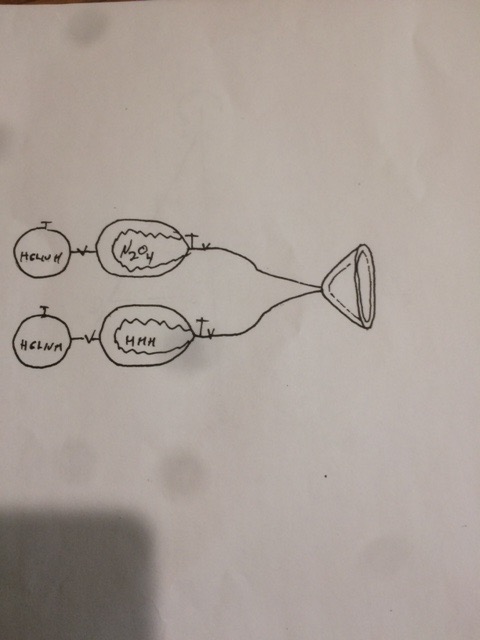
On the bulkhead were a gimbal platform, 2 infrared horizon scanners, pitch, roll and yaw freon gas valves and thrusters, an Inertial Reference Unit (IRU), and rate gyros, in addition to TWO orbit adjust engines. I also believe that the freon cold gas and orbit adjust hydrazine and Nitrogen Tetroxide storage tanks were on the back side of the bulkhead, with plumbing hardware to feed the freon valves or orbit adjust engines fuel when necessary. Likely near the OA fuel and oxidizer tanks behind the bulkhead were two helium tanks, which sent helium into the fuel and oxidizer tanks, to push a bladder to keep pressure on the fuel and oxidizer as it was used during the mission. This was likely implemented to have a good mix of fuel and oxidizer in the OA thrust chamber, which would give rise to a proper mix of the N204 (Nitrogen Tetroxide) and MMH (MonoMethyl Hydrazine) at OA engine on time. In a near zero G environment, who knows where the fuel and oxidizer would be in their tanks as the mission progressed; vehicle rolling, valves firing, payload mirrors being moved, and other perturbations could have caused the MMH and N2O4 to move anywhere, and not be near the OA engine port for use (i. e., mixing in the thrust chamber) when needed. See the sketch below which I found in my archives that shows the hookup. Note valves on output side of the N2O4 and MMH tanks which would be commanded open to start the Orbit Adjust activity. The 209 bulkhead was between the output side of the MMH and N2O4 tanks and the thrust nozzle where the fuels were mixed and combustion occurred when exeeuting an orbit adjust.
It should be noted that most of the hardware on the 209 bulkhead was Stabilization and Control Subsystem hardware; see the Stabilization and Control section of this document for how the 209 bulkhead hardware was configured, controlled and used during the mission.
GROUND CONTROL SOFTWARE
IRT 2 9 11 RUNNUM	(XXX)
GENIE TOSP TMPGP GMINT GCONTACT GCOMMAND – FIRST VERSION
	TPREP TPAT TMOP AND??? – LATER VERSION
		DECK LISTINGS USED AND REVIEWED
		ALTER MODE
		MESSAGES TO RTS’s RETURNED & CHECKED
GTELIM MESSAGE UPDATES HARD W/ANOMALY
		OCTAL CORRECTORS

ON ORBIT TIMELINE:
PUSH TO SHORTEN TO MOVE CLOSER TO LOAD STATION
		TIMELINE CRUNCH
		DAY IN LIFE
The mission planning runs on the CDC 38xx computers were scheduled to start on a strict timeline, as close to the planned command message aim point load data changes for the upcoming message from the intelligence community to be received and used in the upcoming imaging message generation. Suggesting some change that would move the timeline closer to the planned load station was generally well received.
This strict timeline allowed very little margin for problems during the message generation cycle. One tough problem encountered was hardware failure of the computer on which the imaging message run was being executed. This failure meant that computer scheduling was informed to "get us a new computer as quickly as possible, as the one we are on has failed”, and this request could generate controversy, particularly by someone who was about to lose the computer they were running a job on to someone who at the moment had more priority. That being said, this scenario could surface at another time with the two groups being in the opposite position needing a working computer.
I recall a scenario where someone from another program complained that our KH7 program had too much power and got a computer when we needed one more easily than other programs, whereupon one worker who was well thought of stated “I am going back to my office to call General ______ in the Pentagon and ask him to call someone in authority on the other program and ask them to remind his troops that the KH7 program was paying for the computers they were using”.
Switching systems competition generally occurred between various shifts as each shift kept track of how long it took to move from a malfunctioning computer to a new computer and continue the message generation cycle. I recall that the operators that accomplished the switching the fastest generally had a target on their back as other operators tried to unseat the incumbent operators and move to the “fastest time switch” post. The operators that usually had credit for the fastest turnaround were __ &___ or __ & ___.
FOURTH SHIFT AND ITS’ IMPORTANCE
	MCD FROM BEST FIT EPHEMERIS AND CLOCK CORRELATION RUNS AND GTELIN DAILY REPORT –GTELIM HARD AT ANOMALY TIME

PREPRESS BRIEFING AND OTHER - ATTENDEES

TOOLS PRELAUNCH EXECUTION  TO PICK ORBIT
 	TOOLS PROGRAM SEARCH INPUT AND RESULTS
	RESULT PICKED ORBIT FOR NEXT MISSION


	THEN FULL NEW DECK FOR NEXT USE
	ONE HIGH PRI MAYBE FROM OTHER ORG
	AND MAYBE AFTER 1965
One of the first tasks to be accomplished in preparing for a launch was the execution of a TOOLS search run executed in the prelaunch phase to arrive at an optimum orbit for the next imaging mission. I think that the most important input to the TOOLS software program was a small deck of imaging aim points that the intelligence community must have thought were ranked as the most important points needing to be looked at during mission operations for the next launch. I had no insight into how the points were selected for use, and still do not have any insight at this late date; I will leave that to the analysts who requested that certain data be acquired. The input "aim point data" was small in size in relation to a later input received for operational mission use for the next launch. Had the input “aim point data" been the size of that used during mission imaging operations, the TOOLS program would have been computing a LONG time to process all data points! Other input parameters to the TOOLS program were a range of period points (one run for each period input) and the number of days of primary imaging mission coverage desired.
One other item I recall was a request by another intelligence organization asking for capability to insert a high priority aim point into the large mission aim point deck at any time; I believe this was done.
MISSION PROFILE GENERATION AFTER ORBIT PICKED, MEANT  EPHEMERIS GENERATED FOR PLANNED NUMBER OF
MISSION DAYS THEN ACTIVITY SPANs PICKED FOR
		CONTACTS – STATION NAMES
		PAYLOAD
	CONTACTS AND LOAD STATIONS PICKED USING RULES

OA MAINTENANCE EVENTS SET FOR PERIGEE “WALK”
	3 RV RECOVERY SUPPORT STATIONS PICKED
	OCV DEBOOST EVENT SCHEDULED – 							SOMETIMES SHORTLY AFTER
			RV DEBOOST WHEN LOW ON EXPENDABLES
	SECONDARY FLIGHT OBJECTIVES

	DECKS FOR PRIOR MISSIONS SAVED AND AIDED IN			 	LATER PROFILE BUILDS

	MISSION PROFILE ON WALL – SAMPLE

	CARD RUN DECKS FROM WALL DISPLAY

	MANUAL GEN FOR SOME PARTS OF PROFILE

	RUN DECKS WITH SPANS REFINED DURING REHS

	BAD INJECTION RUINED PROFILE/DECKS

	MISSION PROFILE – SAMPLE

	LOAD DECK – SAMPLE
With the completion of the prelaunch Tools program orbit picking task, the next task enroute to getting ready for the upcoming launch was to define the mission profile with some manual inputs by the person responsible for generating the mission profile. This involved utilizing the orbital parameters created by the TOOLS program execution to generate a predicted vehicle ephemeris for the next mission, with the ephemeris span covering the number days of planned mission operations.
The span of the ephemeris was set to 16 revolutions around the earth per day (the normal number of revolutions of the Gambit satellite per day) times the number of days of planned mission operations plus a few revolutions for RV recovery and OCV deboost events which normally occurred a few revolutions after the last imaging pass.
This ephemeris was used as input to several programs to generate data needed to build the profile. Among the data generated using the ephemeris was that used to determine what tracking stations would be available on each revolution, along with how long the vehicle would be visible over each station, and the maximum elevation the tracking station antenna would traverse to on each contact.
SCF tracking stations available for use changed some over the near 4 year lifetime of the Gambit program. Satellite Control Facility (SCF) Tracking stations that I recall being used for most of the program were: COOK (near Vandenberg AFB, California), HULA (near Kaena Point, Hawaii), KODI (near Kodiak, Alaska), BOSS (near New Boston, New Hampshire), and POGO (near Thule, Greenland).
Probably the most important computer run was a mission planning run using as prime input a set of imaging aim points for the next mission. Readers may recall that the input to the TOOLS orbit selection run was a small set of imaging aim points; for this profile data generation run, the input was a much larger set of imaging aim points. Once the orbit was selected by the TOOLS run, I recall that several boxes of 80 column IBM cards that arrived in a communications center from the Intelligence community back east were read and the data from each of them was written to a magnetic tape using a small CDC 160 computer in the Command Generation area. Then, this tape became the prime input to the mission planning run. The data on the tape consisted of data for each imaging aim point, an aim point ID and needed data for each, such as latitude, longitude and altitude, mode, number of looks requested during the next mission, and probably some items I have forgotten about.
I think that once the tape containing mission aim points was read in a mission planning run, then it was not necessary to read the tape again to access data for each aim point. Once the data was read from the 80 column cards during a mission planning run, that then the reformatted data was ready to be read and used without any conversion. At the completion of EACH mission planning run, I believe a file of this data was available for use by the next mission planning run. Prior to initiation of each mission planning run, new or modified imaging aim point data might have be received from the intelligence community; it could be data for a new aim point ID or modification to an existing aim point ID.
I believe this method of modifying data for existing aim points or adding aim new points to the existing aim point data was a computer run time consideration. This will be discussed later in treatise ON ORBIT TIMELNES - PUSH TO SHORTEN. The mission planning runs on the CDC 38xx computers were scheduled to start on a strict timeline, as close to the planned command message load station as possible to allow for reception of aim point load changes as late as possible on the strict timeline.
The mission planning run span for use in mission profile building was set to the number of planned days of imaging data gathering. As an example if the next mission was planned for five days of data gathering, then the run span would be set to generate at least 80 (16 revolutions a day times 5 days equals 80) revs of potential imaging data gathering, followed by several revs more to be used to support of RV recovery activities, with the nominal RV recovery pass probably occurring shortly after the last imaging data gathering revolution, likely on revolution 82 during a three station Pogo, Kodi and Hula set of station contacts.
Station contact data needed would be available, created from a Gcontact program execution using the ephemeris generated, as mentioned a few paragraphs back in this treatise. I believe the first Gcontact run was executed without suppressing any station contacts in order to parse the list of tracking stations that might be included in the various command loads. This then allowed for insertion of station contact commands in command loads using rules to eliminate some of the station contacts in order to conserve power and decrease on time for the vehicle components that had limits on component on times. As an example, on some revolutions there would be MORE than one station contact available for use, and one could pick the one with the longest visibility time over a tracking station as the station to use, meaning the commands for the other stations on that revolution would not be loaded into the onboard command vehicle memory for use.
 EPHEMERIS GENERATED FOR PLANNED NUMBER OF
MISSION DAYS THEN ACTIVITY SPANs PICKED FOR
		CONTACTS – STATION NAMES
		PAYLOAD
	CONTACTS AND LOAD STATIONS PICKED USING RULES

OA MAINTENANCE EVENTS SET FOR PERIGEE “WALK”
	3 RV RECOVERY SUPPORT STATIONS PICKED
	OCV DEBOOST EVENT SCHEDULED – 							SOMETIMES SHORTLY AFTER
			RV DEBOOST WHEN LOW ON EXPENDABLES
	SECONDARY FLIGHT OBJECTIVES

SPECIAL PAYLOAD ISSUES
	CORN EXERCISES - SKETCH
		SLEEPING GND SUPPORT, PLANE SEEN
	SNOW EVENTS
		MANUAL DOWN N STOPS ON FEW IDs
	SPECIAL COLOR/UTB HANDLING
	 	GOOD GLUE
		FINE/COARSE TLM USED TO SCHEDULE
			PLATEN PBF FINE/COARSE TLM
				VIA RTC AND SPC
		RTCS FROM STATION PANICKED 	SOC OPERATOR

	DAILY WX CARDS - LAT/LON/REV 							SAMPLE

ALGORITHM SAMPLE ?
	MINI OAs
	PET/PFA TEAMS
	CLOCK TIME ON EDGE
	INPUT CARDS 80 COLUMNS
		FIELDS AND DESCRIPTIONS
END OF MISSION POST FLIGHT REPORTS – 5 AND 30 DAY
At the end of each mission, two post flight reports were generated by vehicle contractors and, likely, many other organizations. The vehicle contractor reports were required to submit a 5 day ”quick look” report, and a 30 day final report. For GE, The 5 day report was, I recall, generated in Sunnyvale, California and the 30 day report was generated back at the factory in Valley Forge, Pennsylvania.
As I recall, one of the main uses of the 5 day report was to alert the community that analysis of some anomaly uncovered a problem needing to be corrected BEFORE launch of the next vehicle! This corrective action could be hardware or software related, and not necessarily vehicle related. Remember that 37 launches of the G vehicle occurred in 48 months, almost 1 a month, so little time was available to correct a problem and stay on the launch schedule.
The 5 day reporting of a vehicle anomaly could become difficult to have all data needed for investigation of a problem. One problem was related to the end of the mission, the day that occurred and the need for recorded telemetry data tapes from some of the remote stations that could contain telemetry data important to anomaly solution that were still at the remote stations. The stations were awaiting arrival of an aircraft that, as an example, flew to a station once a week to pick up the weeks worth of recorded telemetry tapes on Friday.
Now, assume that an anomaly occurred at that station on Saturday, the day after the plane left the station with data tapes, the mission was completed early during that week and the 5 day report generation clock started. Analysts generating the 5 day report would liked to have had the data off the data tapes still at the remote station, but it would not be available until late Friday or early Saturday, when the plane arrived back in Sunnyvale. So, analysts had the data they had seen before, and, perhaps, some data extracted from the tapes at the remote stations via a request to that station to pull tthe tape from the library and play back data, but they were likely limited in the amount of data they could have that way. The 1200 bit per second data lines could send selected data via use of the Augmentation (Augie) Data System, but at anomaly time, analysts wanted all data on the tape, and, having to live with less data did not make for a 5 day report much fun to generate.
The 5 day report was reviewed by senior company personnel, who, sometimes, took issue with wording, and the initial draft was altered before submission to government customer channels to minimize reporting of controversial statements that might affect incentive fee awards for my company. All in all, the 5 day report work could be stressful at times.
I recall one 5 day report where one group supposedly generated their 5 day report input, made it available for review by our company management before releasing it to customer channels for final review. Then, the majority of that group that wrote that portion of that report all left immediately for Reno to unwind at the gaming tables. Some reviewer wanted to discuss their input, and supposedly elicited the California and Nevada highway patrol to find someone from the group and have them call to discuss their input report!
The 30 day report had the benefit of more data to use in the report. When tapes arrived in Sunnyvale from the tracking stations, copies were made and distributed to contractors, who then made copies to be hand carried or couriered to their factories. In the case if my employer, Valley Forge was the destination of tapes. So, the final 30 day report likely had the benefit of all telemetry data from the vehicle in researching possible causes of vehicle anomalies.
SECURITY NEEDS AND HANDICAPS

COMPUTER SYSTEMS
	CDC 3XXX	SST & AMT – SYSTEM SUPPORT & AUX 			MASTER 	WITH CORRECTOR DECK							ONE TIME 91 CORRECTORS VERSUS A FEW 				LEGAL ONES

		COMPUTER DOWN & SWITCHING SYSTEMS
		MAINTENANCE AND COMPUTER 	PROB
			CLEANING AREA WHEN GIVING UP SYSTEM
		UNCLEARED OPERATORS EARLY ON
			THEN LIST 2
		LTAB CORRS BUT NOT USED
			CDC160 PRINTED OUTPUT
		TAPE DRIVES LATER REMOVABLE
			DISK FOR CDC 3XXX LARGE  MAINFRAME
		CARD PUNCH INCIDENT BROKEN BELT
	BIRD BUFFER, 160A AND OTHERS
	CONTINGENCY PLANS IF POWER 							LOST IN STC
	SIMULATED TO PALO ALTO, ALMOST 	TO  LA
		NEXT SHIFT WAS TO REPORT TO 	MOFFETT
	ADVANCED MAN TO LA ONCE, STAFF CAR
	BACKUP POWER GENERATORS EARLY

GROUND STATIONS – RTS, SCF AND VAN
	MICROWAVE LINK FROM VAFB

COMMUNICATIONS
	BACK LINE, TROPO SCATTER, 1200/2400 BITS
	TTY

MESSAGE PRINTING AND DISTRIBUTION
	DATA HANDLERS, DECOLLATE 6 	PART
	160A PRINTER FROM SO TAPE, NOT ON SYS2X
		1ST 2 TO TA, 1 TO 10A

SECURITY NEEDS AND HANDICAPS

TAPES – COURIER HAND CARRY
	ARMED SURVEILLANCE
	ALSO USED PO BOX FOR DOCS
		USING REGISTERED MAIL
		PO BREAKIN
		PO BOX LOCATION CHANGED

ANOMALIES – TO WALNUT AND TIKI

CREW CROSS FERTILIZATION VS SAME SHIFT

CARDS TO ENT BY MISTAKE

GENERAL ANOMALIES

	BATTERY LOST
	9.28 VS 4.47 PADLOAD TIME ERROR
	DOOR BLOWN OPEN BAD THERMAL STATE
	COMPUTER PREARM

PREPASS BRIEFING
	GROUPS ATTENDING
	SUBJECTS
	PASS PLAN APPROVAL
	PASS PLAN CONTENTS AND SAMPLE
	STATION BRIEF BEFORE VEHICLE ACQ

SUPPORTING GROUPS

201 EFFECT

1962-1965 PRELAUNCH EFFORT INCLUDING REHS

1965-1967 PRELAUNCH EFFORT INCLUDING REHS

NETWORK

REHEARSALS
	REHEARSAL CONDUCTION
		ANOMALIES TO TEST SYSTEM AND PROCS

MUSINGS,  RECOLLECTIONS AND EPISODES
	VENDING MACHINES-CAFETERIA
HOURS NOT GOOD UNTIL LATER - 				WEEKENDS BAD
	PARTIES
		LAMPLIGHTER
		PRIVATE
PARKING AND ETC – STICKERS AND CARD KEYS
KALS BBQ – SAMBOS - ORCHARDS
EMPTY PIPE AND POPSICLE
AF BILLETING AND CAFETERIAS
ROOMS 309 AND 310 – CIRCA 1963 AND CIRCA 2000
COLD WORK AREA-JACKETS
WHIRLIGIG
OCTALS